
OutDoors GPS - Offline OS Maps
In-app purchases
4.0star
564 reviews
100K+
Downloads

Everyone
info


About this app
The #1 Outdoors Navigation App
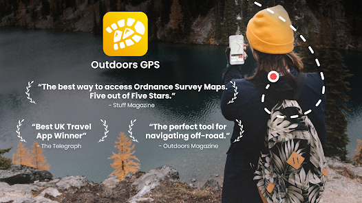
“The best way to access Ordnance Survey Maps. Five out of Five Stars.” -Stuff Magazine
"Best UK Travel App Winner" –The Telegraph
“The perfect tool for navigating off-road.” –Outdoors Magazine
• Trusted by hikers, cyclists, ramblers, and outdoor instructors.
• OutDoors GPS makes it easy to enjoy the great British countryside in confidence.
• At a fraction of the cost of a dedicated GPS device, spend less time staring at maps and more time stretching your legs.
• The only outdoors navigation app that combines all your favorite OS Maps, with the features you need in a simple interface.
• There is now no reason to ever get lost again. Simply create a route on Ordnance Survey maps..…and go!
OutDoors GPS takes outdoors navigation to new heights:
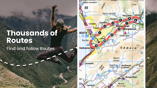
• Hikers: Find or plan a route by choosing from over 200,000 free routes. Then navigate using the built in compass & simple direction view. Track your journey and finally save and share favorite hidden by creating a ‘My Places” list
• Runners: Add variety to your running routes by searching our database of local routes based on distance and elevation. Track your stats & save your favorite places for great views, stretching, resting and water fountains
• Cyclists: Find a route that matches your level of intensity by searching entries by distance and elevation. Or craft your own perfect biking path with the route builder. Use the hands free mode while biking and track your route statistics
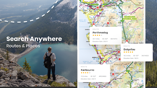
• Photographers: Find beautiful landscapes by searching through over 250,000 points of interests. Find or plan your route to get there by using distance markers and confidently explore offline with Satellite, Terrain, Hybrid, and Road maps
EXPLORE CONFIDENTLY
• Dependable anywhere - Break free of phone signals and download maps to use and explore anywhere
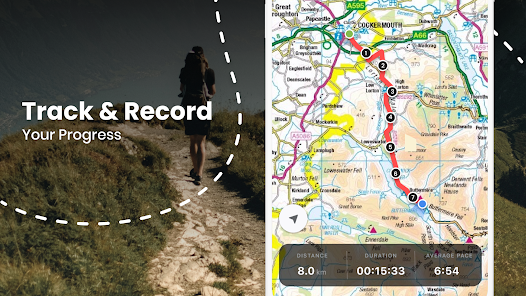
• Find, plan, share, and record routes with statistics & elevation profiles
• 200,000+ Free routes available for route planning on integrated website (outdoorsgps.com)
• Worldwide map coverage with Satellite, Terrain, Hybrid & Road maps
ORDNANCE SURVEY MAPS
• Download any Landranger 1:50k, Explorer 1:25k Ordnance Survey maps (PRO)
• Super fast map display, regardless of signal
POWERFUL GPS FUNCTIONS
• Fully functioning GPS at a fraction of the cost of a dedicated GPS device
• Finds your location in seconds- accurate to within 10 metres
• Create a route, with distance markers, by tapping it out on the screen
• Follow a planned route using the in-built compass & clear direction view
• Hands Free mode (for following a route while cycling)
• Create and Share 'My Places' list (favourite pub, picnic area, great view etc)
• 250,000 points of interest included (with fast search tool)
WEBSITE & ONLINE COMMUNITY (100,000+ MEMBERS)
• Do all your planning (or post trip analysis) with OS Maps.
• Plan, edit and share your routes (via Email, Twitter or Facebook).
You can subscribe to unlimited OS Maps with OutDoors PRO. Your yearly subscription will be £30 from the date of subscription and will automatically renew unless cancelled at least 24 hours before the end of the current period. Auto-renew can be turned off anytime after purchase. No cancellation of the current subscription is allowed during active subscription period. Also access OS Maps on our website: http://outdoorsgps.com
Note: Continued use of GPS running in the background can dramatically decrease battery life.
Terms of Use: http://outdoorsgps.com/terms
Privacy Policy: http://outdoorsgps.com/privacy
“The best way to access Ordnance Survey Maps. Five out of Five Stars.” -Stuff Magazine
"Best UK Travel App Winner" –The Telegraph
“The perfect tool for navigating off-road.” –Outdoors Magazine
• Trusted by hikers, cyclists, ramblers, and outdoor instructors.
• OutDoors GPS makes it easy to enjoy the great British countryside in confidence.
• At a fraction of the cost of a dedicated GPS device, spend less time staring at maps and more time stretching your legs.
• The only outdoors navigation app that combines all your favorite OS Maps, with the features you need in a simple interface.
• There is now no reason to ever get lost again. Simply create a route on Ordnance Survey maps..…and go!
OutDoors GPS takes outdoors navigation to new heights:
• Hikers: Find or plan a route by choosing from over 200,000 free routes. Then navigate using the built in compass & simple direction view. Track your journey and finally save and share favorite hidden by creating a ‘My Places” list
• Runners: Add variety to your running routes by searching our database of local routes based on distance and elevation. Track your stats & save your favorite places for great views, stretching, resting and water fountains
• Cyclists: Find a route that matches your level of intensity by searching entries by distance and elevation. Or craft your own perfect biking path with the route builder. Use the hands free mode while biking and track your route statistics
• Photographers: Find beautiful landscapes by searching through over 250,000 points of interests. Find or plan your route to get there by using distance markers and confidently explore offline with Satellite, Terrain, Hybrid, and Road maps
EXPLORE CONFIDENTLY
• Dependable anywhere - Break free of phone signals and download maps to use and explore anywhere
• Find, plan, share, and record routes with statistics & elevation profiles
• 200,000+ Free routes available for route planning on integrated website (outdoorsgps.com)
• Worldwide map coverage with Satellite, Terrain, Hybrid & Road maps
ORDNANCE SURVEY MAPS
• Download any Landranger 1:50k, Explorer 1:25k Ordnance Survey maps (PRO)
• Super fast map display, regardless of signal
POWERFUL GPS FUNCTIONS
• Fully functioning GPS at a fraction of the cost of a dedicated GPS device
• Finds your location in seconds- accurate to within 10 metres
• Create a route, with distance markers, by tapping it out on the screen
• Follow a planned route using the in-built compass & clear direction view
• Hands Free mode (for following a route while cycling)
• Create and Share 'My Places' list (favourite pub, picnic area, great view etc)
• 250,000 points of interest included (with fast search tool)
WEBSITE & ONLINE COMMUNITY (100,000+ MEMBERS)
• Do all your planning (or post trip analysis) with OS Maps.
• Plan, edit and share your routes (via Email, Twitter or Facebook).
You can subscribe to unlimited OS Maps with OutDoors PRO. Your yearly subscription will be £30 from the date of subscription and will automatically renew unless cancelled at least 24 hours before the end of the current period. Auto-renew can be turned off anytime after purchase. No cancellation of the current subscription is allowed during active subscription period. Also access OS Maps on our website: http://outdoorsgps.com
Note: Continued use of GPS running in the background can dramatically decrease battery life.
Terms of Use: http://outdoorsgps.com/terms
Privacy Policy: http://outdoorsgps.com/privacy
Updated on
Safety starts with understanding how developers collect and share your data. Data privacy and security practices may vary based on your use, region, and age. The developer provided this information and may update it over time.

No data shared with third parties
Learn more about how developers declare sharing

This app may collect these data types
Location, Personal info and 3 others

Data is encrypted in transit

You can request that data be deleted
Ratings and reviews
3.8
497 reviews

Neil Purnell
- Flag inappropriate
January 13, 2024
Potential to be excellent but simply doesn't work as described. Works great whilst you've got a data signal but sold as being able to download maps for offline use. Maps will not download, so if you're thinking of going off the beaten track (no data signal) be prepared to get lost. Problem has been about for a long time. I don't think it should be available to install until the problem is resolved and I'm surprised Google Play Store allow it to be available.
13 people found this review helpful

A Google user
- Flag inappropriate
September 11, 2019
Like others, have paid for individual maps, but am now unable to download them to my device. The new UI looks slick, but does not hide the serious issues currently blighting the app. Hopefully a fix soon, but it looks as if the developer want to push away established users of the app to build a subscription-based model. If a fix is not in evidence soon, I will be asking for the app to be removed from the Play store and my money returned.
40 people found this review helpful

Rebekah Wilkinson
- Flag inappropriate
- Show review history
June 16, 2021
Good app for walking. Easy to use and doesn't drain the battery too much when out. Used to be better in that you could buy the OS map for individual counties/national parks but now you have to subscribe to get access to those. I've still got the ones I bought a few years ago but can't add any more without subscription. And improvement would be the shared routes from the community - you can't see them on the map before downloading so adding that functionality would help.
41 people found this review helpful
What's new
* Bug fuxes


